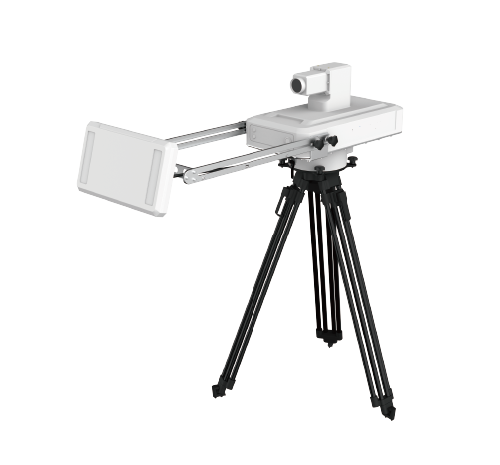
Products / Slope Stability Monitoring Radar System

Slope Stability Monitoring Radar System

The CA-R210 slope stability monitoring radar system is a 360-degree omni-directional scanning real-time slope radar, mainly used for high-precision real-time slope deformation monitoring and early warning, as well as landslide monitoring support during emergency rescue. It can be used for deformation monitoring and early warning of large open-pit mine slopes, mountains, slopes along railways and highways, tunnels and bridges, and so on. It features long-distance non-contact operation, high-precision real-time rapid measurement, omni-directional continuous online measurement, all-day and all-weather operation unaffected by cloud, rain or fog, immunity to the influence of moving vegetation or animals, flexible deployment with simple erection and maintenance, and 3D interface display and early warning. With high reliability and high accuracy, it can be used for terrain deformation monitoring tasks in natural disasters such as geological hazards, mountain landslides and landslide emergency rescue.

Slope Stability Monitoring Radar System

Overview

The CA-R210 is available in fixed and detachable forms, offering high deployment flexibility and suitability for long-term monitoring and emergency monitoring. It supports DC, AC and solar panel power input, supports various communication methods including 4G, WiFi, wired and radio, supports an open user interface, and features a waterproof and shock-resistant design suited to harsh field working environments.

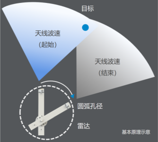
The rotating arm pivoting about its axis drives the wide-beam antenna at its tip to sweep across the target, performing arc synthetic aperture high-resolution imaging; phase interferometric processing achieves sub-millimetre deformation measurement accuracy.

Applications

  • Open-pit mine slopes, highway and railway slopes, spoil grounds, reservoir and dam slopes, and so on.

Key Features

  • 360° scanning
  • Circular rotation supports 360° omni-directional scanning; ArcSAR synthetic aperture real-time imaging with phase interferometric processing outputs complex scattering and deformation data.
  • Supports configurable scanning angle and speed;
  • Supports turntable levelling and manual pitch adjustment of the radar antenna;
  • One transmitter and one receiver; on-site users can adjust the antenna pitch;
Specifications

ParameterValue
Anti-interferenceNon-contact measurement, working around the clock and unaffected by cloud, rain or fog;
OTAThe deformation of the building being monitored. This instrument is certified by an authoritative national metrology institution and has been verified through extensive engineering
FormLightweight and easy to carry: it can be taken on aircraft, high-speed rail, SUVs, cars and other mainstream modes of transport, and can be carried or towed; no counterweight is required.
Optical lensSupported on the host unit, with on-site image capture and transmission (network camera)
Interference filteringMeasurement results are unaffected by moving vegetation, moving animals or vehicle movement
Performance Specifications ListNo.
Description1
Update Rate≥1 time/minute (180° scene azimuth, including deformation data processing time)
Maximum detection distance≥5000 m
Maximum single azimuth coverage angle360° (360° imaging supported)
Antenna pitch beam angle30°/45°
Deformation measurement accuracyBetter than ±0.1 mm;
Overall power consumption≤40 W (radar host, turntable and processing equipment, excluding gateway and host computer)
Circular scanning radius≤0.5 m
Protection capabilityThe overall protection rating of the unit is not less than IP65.

Product Gallery

Need this instrument?

Contact us for pricing, lead time and technical support.

Contact Us